Technical Tours Schedule and Descriptions
General Information
- No technical tours scheduled for Monday, October 6.
- All times are given in local time (ET).
- Participants must bring their own steel-toed footwear, when they are required.
- All other personal protective equipment will be provided by the Ministère des transports et de la Mobilité durable du Québec.
- Registration for technical tours opens June 17. Only one tour is permitted per registration, as seats are limited.
If you have any questions or need additional information, contact us at conference@tac-atc.ca.
Coming August 5
– New Tours Available!
Mark your calendar! A fresh round of tours opens for booking on August 5 at noon (ET) — including sponsor-led experiences and additional official TACConf Technical Tours organized by our Local Organizing Committee.
Stay tuned for full details and get ready to reserve your spot!
Looking for some walking tour ideas to explore Québec City as a tourist?
- Guided Walking Tours
- Self-Guided Adventures
- Food Tours

Looking for some walking tour ideas to explore Québec City as a tourist?
Visit our Discover Québec webpage

Looking for some walking tour ideas to explore Québec City as a tourist?
Visit our Discover Québec webpage
Find a Tour
Find a Tour
Sunday Tours
Traffic Management Center
- Schedule: Sunday, October 5, 13:00-14:30
- Capacity: 24 Participants
- Mode of Transportation: Bus
The Traffic Management Center ensures effective management of the Ministry’s road network, both in terms of prevention and intervention, to ensure user safety and facilitate province-wide travel. Operating 24 hours a day, 365 days a year, this essential service monitors the network, alerts emergency services and supports recovery operations.
Tuesday Tours
Autoroute Henri-IV (A73) in Québec City – Landscape, architectural and environmental features
- Schedule: Tuesday, October 7, 8:30-11:30
- Capacity: 25 Participants
- Mode of Transportation: Bus
This three-stop tour features major environmental and architectural interventions:
- Boulevard Des Quatre-Bourgeois bridge: integrated design to reduce the urban divide
- Charest/Henri-IV retention basin: simulated wildlife habitat
- Félix-Leclerc/Henri-IV basins: award-winning ecological design (PIARC 2019)
- Integrated landscaping with topography, planting and visual structures
Personal Protection Equipment (PPE) required:
- Provided: Hard hat and safety vest
- Not provided: Steel-toed footwear
Adding Reserved Lanes
- Schedule: Tuesday, October 7, 8:30-11:30
- Capacity: 25 Participants
- Mode of Transportation: Bus
This joint project between STLévis and the City of Lévis adds reserved lanes on boulevard Guillaume-Couture, including the following elements:
- 3 km road widening (in two sections)
- Improving public transit fluidity
- Addition of bike paths and sidewalks
- Observation of completed sections and work in progress
Personal Protection Equipment (PPE) required:
- Provided: Hard hat and safety vest
- Not provided: Steel-toed footwear
Île d'Orléans – New Bridge Project
- Schedule: Tuesday, October 7, 8:30-11:30
- Capacity: 25 participants
- Mode of Transportation: Bus
This site visit will focus on several key aspects, including:
- Challenges related to a heritage and natural site
- Temporary marine structures (jetties, booms, barges)
- Temporary installation of liquid stabilizer
- Environmental mitigation measures
Personal Protection Equipment (PPE) required:
- Provided: safety vest, safety glasses, gloves and type-2 hard hat with chinstrap
- Not provided: steel-toed footwear
Tête des Ponts Construction Site
- Schedule: Tuesday, October 7, 9:00-11:30
- Capacity: 25 Participants
- Mode of Transportation: Bus
This tour will showcase several construction projects in the vicinity of the Aquarium du Québec, including:
- Redevelopment of avenue des Hôtels into an urban boulevard with a bus corridor
- Multi-purpose trail along Route 175
- Viewpoint overlooking the northern approach to the Pont de Québec
- Two overpasses spanning the railway line
- New pedestrian link between Avenue des Hôtels and the Via Rail station
- Bus tunnel in the Laurier sector
Personal Protection Equipment (PPE) required:
- Provided: Hard hat and safety vest
- Not provided: Steel-toed footwear
Pavement Laboratory – Research Complex
- Schedule: Tuesday, October 7, 14:00-16:30
- Capacity: 30 Participants
- Mode of Transportation: Bus
This tour includes a visit to the laboratory facilities, showcasing the equipment and tests used for research, development, and quality control of infrastructure materials.
Personal Protection Equipment (PPE) required:
- Provided: Safety glasses
- Not provided: Steel-toed footwear
Intelligent Mobility Management Center
- Schedule: Tuesday, October 7, 14:00-16:30
- Capacity: 12 Participants
- Mode of Transportation: Public Transportation
The CGMI engineers and technicians use a state-of-the-art centralized traffic signal management system, the first of its kind in Canada. This system enables instantaneous intervention to reduce the frequency and duration of congestion events.
Wednesday Tours
Rue de la Faune Construction Site
- Schedule: Wednesday, October 8, 8:30-11:00
- Capacity: 20 Participants
- Mode of Transportation: Bus
This tour focuses on work underway on bridges P-20178E/W, including:
- Backfilling in progress with observation of techniques and materials
- Exposed deck slab (uncovered), underside visible
- Formwork and reinforcement for transition slabs (possible)
Personal Protection Equipment (PPE) required:
- Provided: Hard hat, safety vest and safety glasses
- Not provided: Steel-toed footwear
Québec Government Air Service (SAG)
- Schedule: Wednesday, October 8, 8:30-11:30
- Capacity: 25 Participants
- Mode of Transportation: Bus
This tour includes a presentation of SAG’s services, a visit to the Quebec City hangar, and a talk by Lynda Roy, General Manager. Topics will include:
- Forest fire fighting (SOFEU)
- Search and Rescue (SQ)
- Medical transport (ÉVAQ)
- Charter services for government departments and agencies
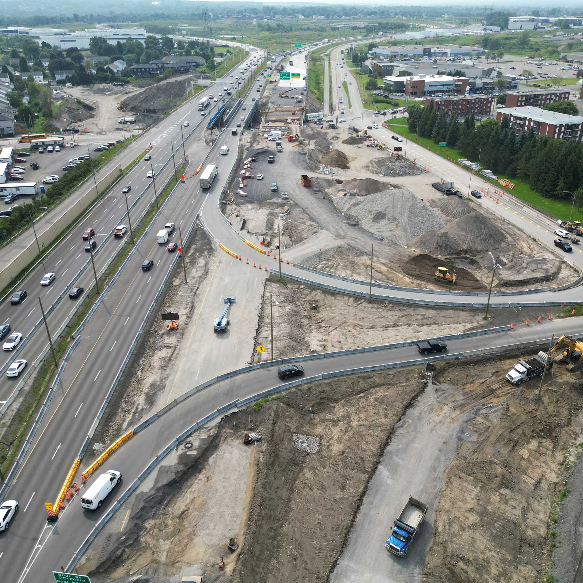
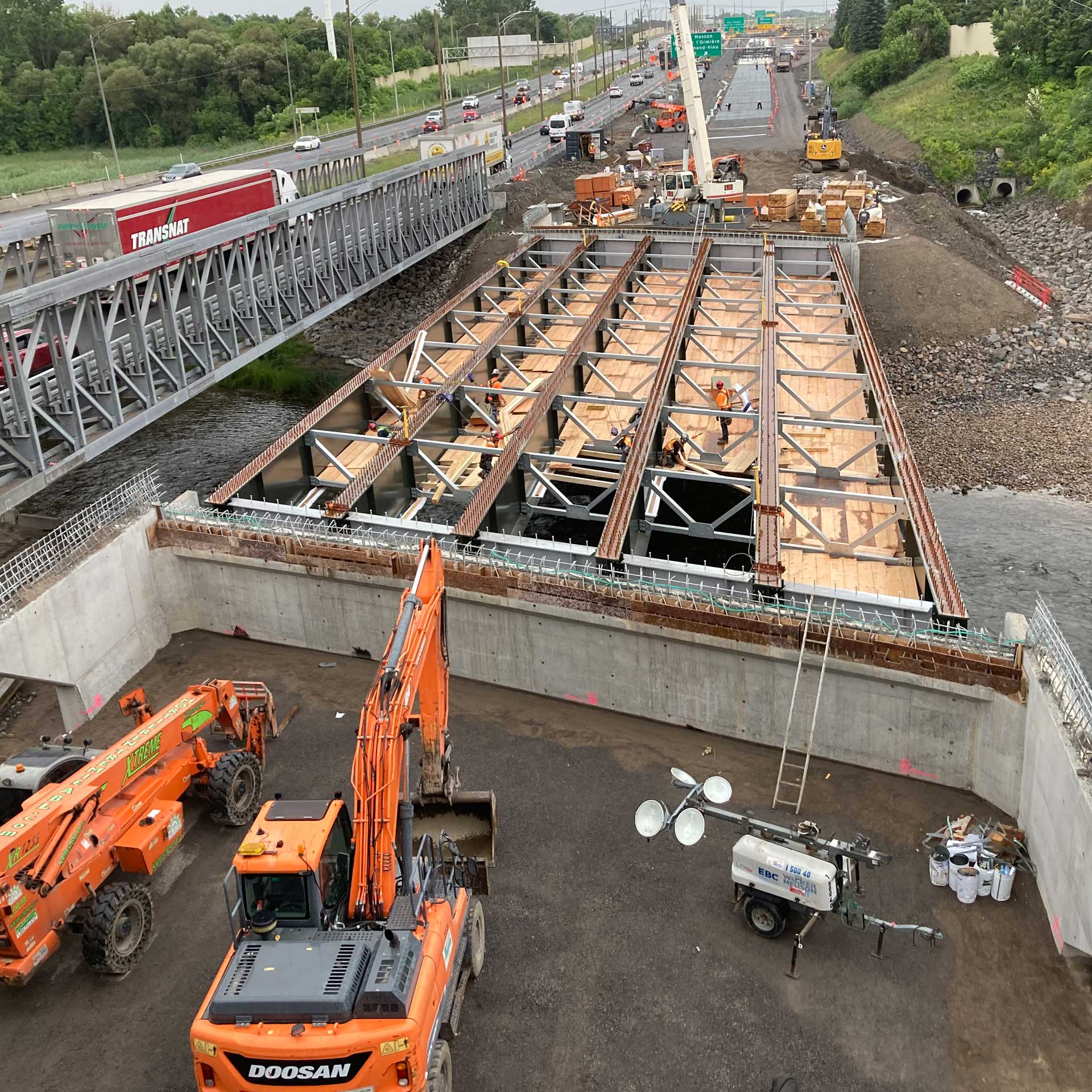
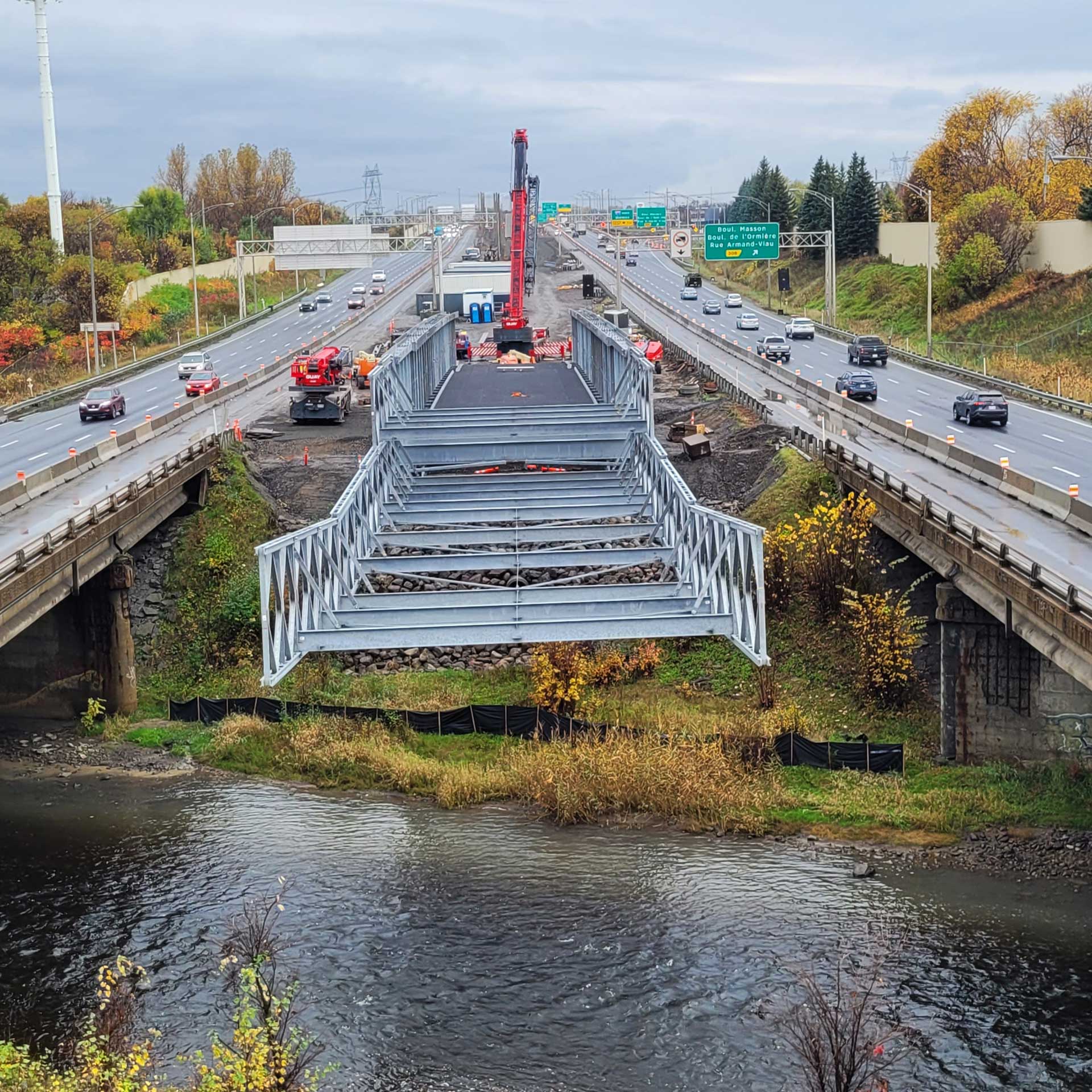
40 Construction Site (Masson / l’Ormière)
- Schedule: Wednesday, October 8, 13:15-15:45
- Capacity: 20 Participants
- Mode of Transportation: Bus
This tour will showcase roadway and bridge rehabilitation work on Autoroute Félix-Leclerc (A-40), in the areas of Rivière Saint-Charles and Masson / L’Ormière boulevards. Highlights include:
- Reconstruction of four roadway bridges
- Refurbishment of concrete pavement, lighting and fibre optics
- Construction of two temporary bridges and road segment to maintain traffic flow
- Recovery of materials and invasive plant management
Personal Protection Equipment (PPE) required:
- Provided: Hard hat, safety vest and safety glasses
- Not provided: Steel-toed footwear
Pierre-Laporte Bridge
- Schedule: Wednesday, October 8, 13:15-16:00
- Capacity: 25 Participants
- Mode of Transportation: Bus
This tour will explore the Pierre-Laporte Bridge, Canada’s longest suspension bridge, and will include visits to the steel deck structure and anchor chambers.
Personal Protection Equipment (PPE) required:
- Provided: Hard hat with chinstrap, class 2 orange safety vest, gloves and safety glasses
- Not provided: Eight-inch steel-toed safety boots
Tour day to be announced
Bike Tour
- Schedule: TBA
- Capacity: TBA
- Mode of Transportation: Bicycle
DETAILS TO COME